


Western Pennsylvania is experiencing a severe cold snap, with temperatures plunging well below freezing and wind chills reaching sub-zero levels. This extreme weather has led to widespread school delays and closures across the region, impacting daily routines for thousands of students and families.
Key Takeaways
- Wind chills are currently as low as -11 degrees Fahrenheit in some areas.
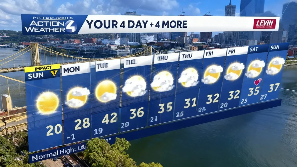
- Pittsburgh Public Schools announced a two-hour delay for Monday.
- Dozens of other schools in Western Pennsylvania have adjusted schedules.
- Temperatures are expected to rise above freezing by Tuesday, ending a long cold streak.
Extreme Cold Impacts Region
Residents woke up to a frigid Sunday morning, with many areas reporting wind chill values significantly below zero. In Pittsburgh, the 'feels like' temperature was recorded at six degrees below zero. Waynesboro experienced even colder conditions, feeling like nine degrees below zero, while Greensburg hit an alarming eleven degrees below zero.
The bitter cold is not just a morning phenomenon. Wind chills are expected to remain sub-zero or in the lower single digits throughout Sunday. Air temperatures are projected to fall just below zero tonight, and even a light breeze will push the 'feels like' temperatures further down.
Coldest Spot
Greensburg recorded the lowest 'feels like' temperature at -11 degrees Fahrenheit.
School Schedules Adjusted for Safety
The severe weather has prompted numerous educational institutions to alter their schedules for Monday, February 9, 2026. Pittsburgh Public Schools announced a two-hour delay, aiming to ensure student safety during the coldest morning hours. This decision affects a significant number of students within the city.
Beyond Pittsburgh, dozens of other school districts across Western Pennsylvania have implemented similar measures. These include modified schedules, remote learning options, or outright closures. The primary concern is protecting students from exposure to dangerously low temperatures and wind chills.
"The safety of our students is always the top priority. Adjusting school schedules allows us to avoid the most extreme cold temperatures for travel," commented a local school official regarding the delays.
Longest Sub-Freezing Streak Nears End
This cold snap marks one of Pittsburgh's longest periods below freezing since January 22nd. The city has endured a prolonged stretch of bitter temperatures, making the anticipated thaw a welcome change for many.
While Sunday remains bitterly cold, with a high of only 28 degrees Fahrenheit, the forecast for Monday offers a slight improvement. Temperatures are expected to reach around 28 degrees, with wind chills moderating into the 20s by the afternoon. This shift signals the beginning of a warming trend.
Understanding Wind Chill
Wind chill describes how cold it feels outside to the human body, taking into account both the air temperature and wind speed. Stronger winds can make cold temperatures feel much colder, increasing the risk of frostbite and hypothermia.
Looking Ahead: A Gradual Thaw
The region can look forward to a significant warming trend starting Tuesday. The forecast predicts high temperatures reaching the lower 40s in Pittsburgh, marking the first time temperatures will climb above freezing since January 22nd. This will bring an end to the extended period of sub-freezing conditions.
The rest of the week will see temperatures in the low to mid-30s, a considerable improvement from the current deep freeze. While some stray sprinkles or flurries are possible late Tuesday night into Wednesday, significant accumulation is not expected. The warmer temperatures will begin to melt some of the accumulated ice and snow.
- Monday: High near 28°F, 'feels like' temperatures in the 20s by afternoon.
- Tuesday: High near 42°F, ending the sub-freezing streak.
- Wednesday: High in the mid-30s, possible isolated sprinkles/flurries.
- Thursday: High in the low 30s.
Residents are advised to continue exercising caution, dressing in layers, and limiting outdoor exposure until temperatures consistently rise. The transition from extreme cold to above-freezing conditions will bring relief, but winter weather hazards will still be present.